
Northern California is currently suffering from some of the worst wildfires the state has ever seen, including the ongoing Mendocino Fire, which is now the largest fire in recorded history.
The California wildfires continue to devastate the US state, with more than ten people dead and 820,000 acres burned so far. The Carr Fire in Northern California has claimed eight lives, making it the deadliest fire this year. The blaze has been 61 percent contained. The Mendocino-Complex Fire, which is the largest wildfire ever recorded in the state’s history was 67 percent contained as of Saturday, 11th August 2018. Officials have stated that they will not have full containment until early September, this year.
Since 2000, fires in California account for approximately ten percent of the land burned in the USA.
The rise of blazes, seen over the last few decades, is believed to be a result of multiple trends, where climate change is a major factor. “Climate change has lengthened the fire season, housing sprawl is creeping into the fire-prone wild land, and fire agencies are struggling to coordinate holistic fire and land management,” said Stephen Pyne, a professor at Arizona State University.
The 2018 fire season is to be one of California’s worst ever.
The Thomas Fire that torched California in 2017 caused historic levels of death and destruction with statistics of burning 283,800 acres in Ventura and Santa Barbara. Last year, the federal government spent over $2.39 billion on firefighting alone.
Mendocino Fire Continues to Grow as California’s Biggest Wildfire
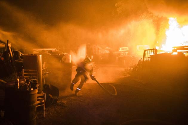
Mendocino complex. (Source: Public Domain)
The Mendocino-Complex Fire has largely been contained, but it is still growing. Technically, this fire has been reported to be two fires with a common origin: the large and unruly, Ranch Fire, and the smaller and lesser-aggressive, River Fire.
The location for the Mendocino-Complex, which started in July 2018, seems to be Highway CA-20 at MP 39, Old Lake County Highway, Blue Lake, 8 miles northeast of Ukiah (Ranch Fire) and Old River Road, and 6 miles north of Hopland (River Fire).
According to the latest information, as of August 13, 2018, the Ranch Fire has covered 282,479 acres, out of which 62 percent is contained; the River Fire covered 48,920 acres, out of which 93 percent is contained. The expected date of full containment is September 1, 2018.
The Carr Fire
The Carr Fire has burned 191,211 acres so far. This fire is north of the Mendocino-Complex in Shasta and Trinity Counties. The location of the calamity is Highway 299 and Carr Powerhouse Rd, Whiskeytown. The cause was reportedly from mechanical failure of a vehicle on July 23, 2018.
The Carr Fire in Northern California has claimed eight lives, making it the most deadly fire yet. The blaze was 61 percent contained, as of August 11, 2018.
Continued hot and dry conditions with gusty winds call for a Red Flag Warning, as of the latest orders. The fire’s spread was driven by the fuel and topography of the region. Mandatory evacuations remain for Whiskeytown Park and Rainbow Lake in Shasta County and Trinity Dam at Trinity Dam Blvd in Trinity County.
The Ferguson Fire
The Ferguson Fire is located right outside of Yosemite National Park at Highway 140 and Savages Trading Post. The fire is currently 95, 946 acres in size and is 83 percent contained, as of August 13, 2018. There have been two fatalities and eleven injuries, and about ten structures destroyed.
The Ferguson Fire is now the largest fire in the Sierra National Forest's history, which began on July 13, 2018.
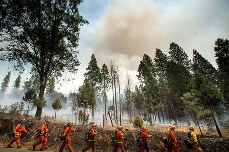
The Ferguson Fire is now the largest fire in the Sierra National Forest’s history. (Source: Getty Images)
Firefighters expect the fire to become more active during the days ahead, as they try to prevent the further spread into Yosemite National Park. The uncontained fire along Wawona Road remains the prime focus of operations. A large portion of Yosemite National Park is open. Tioga Road from Tioga Pass to White Wolf is open to all visitors and vehicles. Most of the trails and campgrounds along this route, including the Tuolumne Meadows Campground are open. Visitor services along Tioga Road, including the High Sierra Camps and the Tuolumne Meadows Store, are also open. The expected date of full containment is August 15, 2018.
Nearly 14,000 firefighters, many of them from out of state, are battling the front lines of the 17 wildfires across California. In addition to nationwide crews helping tame the blazes, a group of 41 firefighters also arrived at the Mendocino-Complex Fire, after a 13.5-hour flight from New Zealand.
Holy Fire
The Holy Fire raging in Cleveland National Forest is 52 percent contained but has spread to 22,714 acres. The inferno broke out last Monday (i.e., around August 6, 2018) in Holy Jim Canyon in Orange County, south-east of Los Angeles. Mandatory evacuation orders remain in place for several communities, forcing more than 21,000 people from their homes in and around the city of Lake Elsinore.
Humans are to Blame for the Wildfires?
According to Cal Fire Deputy Chief, Scott McLean, “Folks believe the rains came and took care of the problem.” The truth is that in spite of heavy precipitation two years ago, the landscape is parched and the groundwater has been depleted.
He also added, “They exacerbate the problem by promoting growth. Our grass growth has been very significant in recent years, and that has added fuel to these fires. It just takes a spark. We need several years of significant winters to get us back to the place we were before.”
Another quotient to the problem is that forests have suffered through years of drought and insect infestation for 2 million dead trees a month, as per the State’s estimation. “The fact is millions of trees die every year, and there are millions of little seedlings that don't make it,” said Keith Gilles, Dean of the College of Natural Resources at UC Berkeley. “But when you have this many big trees dead, it's pretty different. The fuel load is very high.”
According to a study conducted by Michael L. Mann, between 1940 and 2000, nearly 10 million housing units were constructed throughout California. It is estimated that the state's exurban land classes will replace approximately 12 million acres of wild and agricultural land with increasing threats of ecological change and wildfires. Scientists suggest that the number of houses in the high-risk zone for wildfires will increase by nearly 1 million.
It is time that scientists, policymakers, and stakeholders come forward to face the crisis of threatening climate change scenarios.
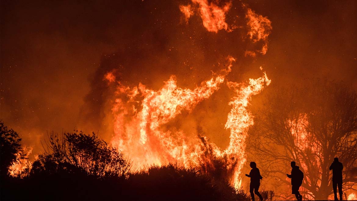
Top Image: Picture of Thomas Fire in northern California, as seen by motorists in Dec 2017. (Source: AP Photo/Noah Berger)
References
Mann et al (2014), Modeling residential development in California from 2000 to 2050: Integrating wildfire risk, wild land and agricultural encroachment. Science direct – Land use policy, 41 (2014), 438-452.
National Significant Wild Land Fire Potential Outlook, 2018. Available at: https://www.predictiveservices.nifc.gov/outlooks/monthly_seasonal_outlook.pdf
Calfire. Available at: http://www.fire.ca.gov/current_incidents


No comment